
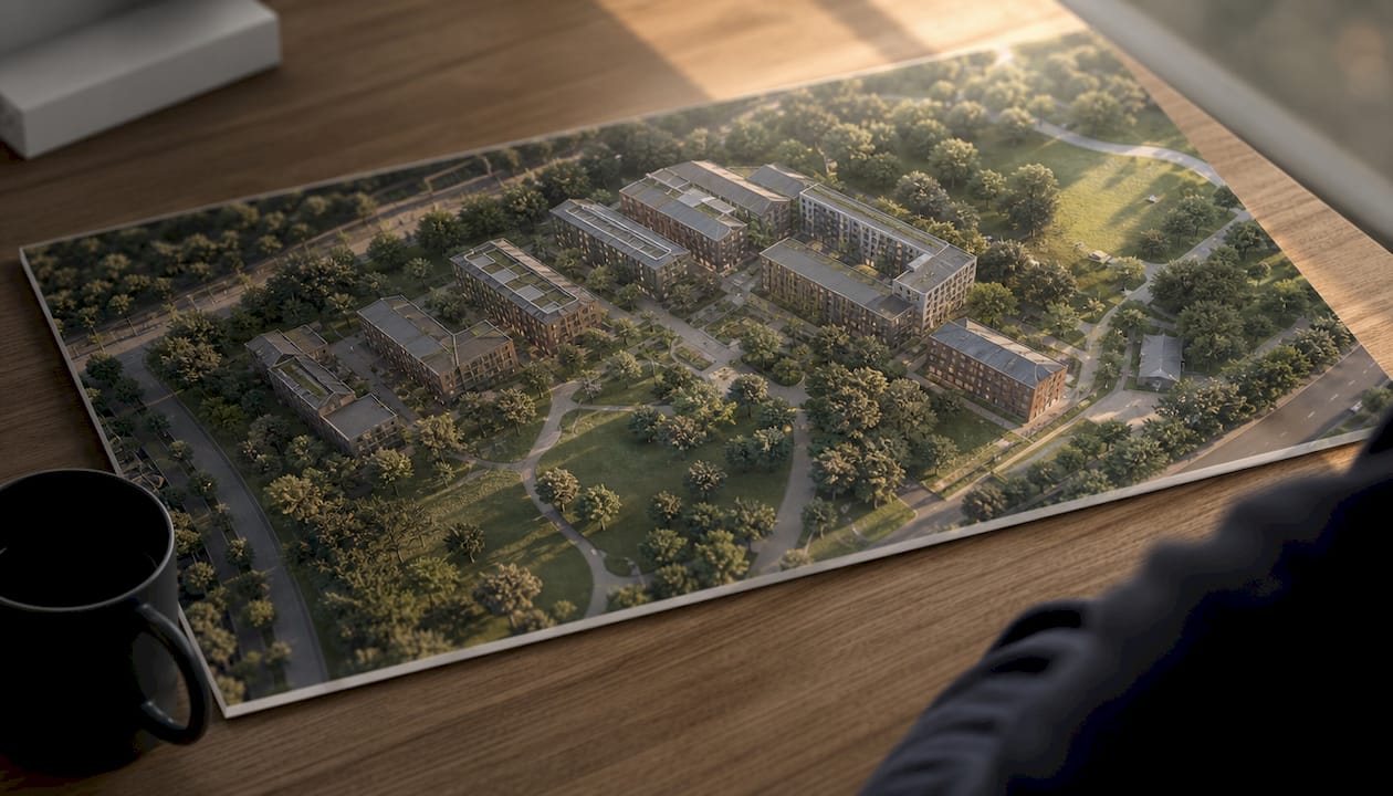
Landscape CGI visualisation is the process of creating accurate, computer-generated representations of outdoor environments to support design, planning, and stakeholder communication. The industry term for this practice is architectural and landscape visualisation, and it sits at the intersection of 3D modelling, environmental simulation, and planning compliance. For real estate professionals, landscape designers, and project managers, understanding what this process involves is the difference between a planning application that convinces and one that stalls.
The process draws on established methodologies including GLVIA3 (the Guidelines for Landscape and Visual Impact Assessment, third edition), which governs how visual impacts are measured and presented to planning authorities across the UK. Visualtrick produces planning-ready CGI outputs that meet these standards, from verified photomontages to immersive 360-degree panoramas. The core workflow moves through data capture, 3D modelling, texturing, lighting simulation, rendering, and iterative client review.
What does landscape CGI visualisation involve, step by step?
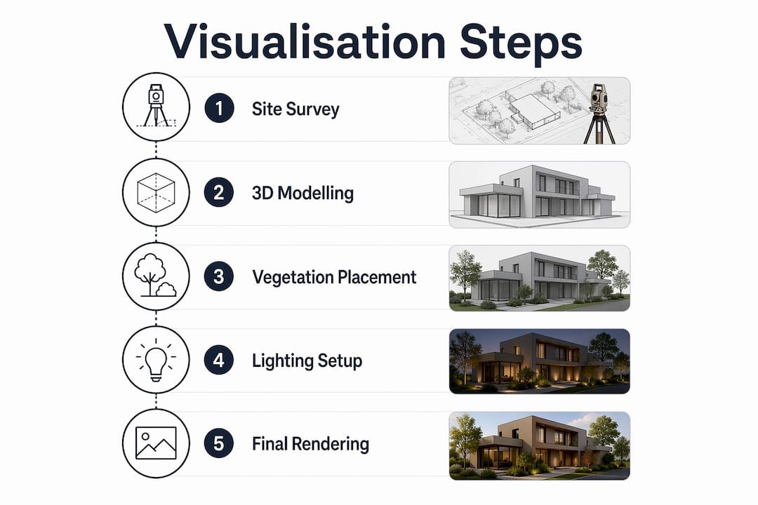
The production process follows a defined sequence, and each stage builds directly on the last. Skipping or rushing any stage introduces errors that compound through the workflow.
-
Site data capture. The process begins with a site survey, measured drawings, and a comprehensive photographic record. Accurate baseline data is the foundation of every credible visualisation. Drone surveys and LiDAR point cloud scans are increasingly standard for larger or more complex sites.
-
Terrain and 3D modelling. Artists build the terrain model first, then add structures, hard landscaping, and vegetation. Vegetation modelling is the most time-intensive element because plant species, scale, and seasonal state all affect the visual outcome.
-
Texturing and materials assignment. Every surface receives a material: grass, stone, timber, water, and soil each behave differently under light. Physically based rendering (PBR) materials replicate real-world reflectance values, which is what gives modern CGI its photographic quality.
-
Lighting and environmental simulation. The sun position is set to match the site’s geographic coordinates and the time of year specified in the brief. Sky conditions, atmospheric haze, and shadow angles are all controllable variables. This matters enormously for planning visuals, where shadow impact on neighbouring properties is often a formal assessment criterion.
-
Rendering and output formats. Final outputs range from static high-resolution images to 360-degree panoramas and virtual reality (VR) experiences. 360-degree panoramas and VR replace static 2D drawings with immersive 3D, improving transparency and speeding up decisions.
-
Iteration and client review. CGI is not a single-pass process. Feedback loops between the visualisation team, the designer, and the client refine camera angles, planting schemes, and material choices before the final render is produced.
Pro Tip: Lock your viewpoints and sun angles before committing to final renders. Changing a verified view after rendering restarts the compliance process and adds cost.
How does landscape CGI visualisation support planning and visual impact assessments?
Major UK planning applications commonly require a Landscape and Visual Impact Assessment (LVIA) or a Townscape and Visual Impact Assessment (TVIA), particularly for tall buildings or sites with landscape sensitivity. These assessments follow GLVIA3 methodology and involve baseline analysis alongside quantitative impact measurement. CGI is the primary tool for producing the verified views and photomontages that planning authorities use to evaluate those impacts.
A townscape CGI visualisation serves a specific function within a TVIA: it shows how a proposed development alters the character of the built environment as seen from defined public viewpoints. The distinction between an LVIA and a TVIA is largely one of context. An LVIA focuses on open countryside and landscape character areas, while a TVIA addresses the urban grain, building lines, and visual amenity of existing townscapes.
The visualisation methods used in formal assessments include:
- Wireframes and Zone of Theoretical Visibility (ZTV) mapping, which identify where a development will be visible before detailed modelling begins
- Photomontages, which overlay a rendered 3D model onto a calibrated site photograph to show the proposed change accurately
- Verified views, produced to SNH and Landscape Institute guidance, using fixed camera positions, known focal lengths, and georeferenced coordinates
- 3D Gaussian Splatting and point cloud data, which are emerging methods for reducing subjectivity in visual impact evidence by incorporating structured, stage-comparable data
A CGI landscape visual impact assessment also considers receptor sensitivity, magnitude of change, cumulative impact, and mitigation measures. The table below summarises the key assessment criteria and their CGI outputs.
| Assessment criterion | CGI output used |
|---|---|
| Receptor sensitivity | Verified views from identified sensitive viewpoints |
| Magnitude of visual change | Before-and-after photomontages |
| Landscape character impact | Aerial and eye-level 3D renders |
| Cumulative impact | Multi-scheme composite visualisations |
| Mitigation effectiveness | Phased planting and screening renders |
What are the practical benefits of landscape CGI visualisation for project stakeholders?
3D CGI communicates complex ideas clearly, reducing misunderstandings and material waste by improving stakeholder clarity. That benefit compounds across every stage of a project, from initial feasibility through to post-planning marketing.
The practical advantages for real estate professionals, landscape designers, and project managers are concrete:
- Early design testing. CGI allows iteration on-screen rather than on-site, enabling teams to test levels, boundaries, and lighting before any ground is broken. This prevents the expensive physical adjustments that arise when design assumptions are not tested until construction.
- Stakeholder alignment. A photorealistic render communicates spatial relationships that a plan drawing cannot. Clients, planners, and members of the public all read a CGI image without needing technical training.
- Marketing and investor engagement. Post-planning, the same CGI assets support brochures, property listings, and investor pitches. The visualisation work done for a planning application has a second life in the sales process.
- Demonstrating future landscape evolution. Planting schemes look sparse at year one and mature at year fifteen. CGI can show both states, which is particularly persuasive for schemes where landscape mitigation is a planning condition.
- Interactive and immersive outputs. VR walkthroughs and 360-degree panoramas allow stakeholders to experience a proposed scheme spatially, not just visually. This format is increasingly requested by planning committees for major applications.
One limitation deserves acknowledgement. Planting visualisations are representational approximations. The exact form of a mature tree or hedgerow cannot be predicted with certainty, and planning authorities understand this. The standard is accuracy of intent, not botanical precision.
Pro Tip: Commission your CGI at feasibility stage, not just at planning submission. Testing design assumptions early costs far less than revising a scheme after pre-application consultation.
What technical challenges arise in complex landscape CGI projects?
Large-scale landscape scenes create specific production problems that do not appear in architectural interior work. The primary challenge is scene performance: a single mature oak tree may contain millions of polygons, and a woodland of several hundred trees can make a scene unworkable on standard hardware.
ForestPack, a procedural vegetation distribution tool, addresses this by instancing vegetation assets across a terrain without multiplying the polygon count proportionally. The result is a scene that renders accurately but remains responsive during the modelling and lighting stages. This approach is now standard practice for nature recovery and large-scale landscape CGI projects.
Master scene referencing using XRef allows multiple artists to work on different parts of a large landscape project simultaneously. Each artist works on a referenced sub-file, and the master scene assembles the components without loading every element into memory at once. This improves both scene performance and collaborative workflow on complex commissions.
The best practices for managing data integrity across a large landscape project include:
- Maintaining a single georeferenced coordinate system from survey data through to final render
- Using layer-based scene organisation so vegetation, structures, and terrain can be isolated and updated independently
- Archiving intermediate render passes (diffuse, shadow, reflection) separately, which allows post-production adjustments without re-rendering the full scene
- Documenting camera positions and lens settings in a verified view register, so any viewpoint can be reproduced exactly if the scheme changes
Key takeaways
Landscape CGI visualisation is the most direct way to test design assumptions, satisfy GLVIA3-compliant planning requirements, and communicate spatial change to every project stakeholder.
| Point | Details |
|---|---|
| Defined production workflow | The process moves from site survey and 3D modelling through to rendering and client review in a fixed sequence. |
| Planning compliance requirement | Major UK applications require LVIA or TVIA outputs, including verified photomontages produced to GLVIA3 standards. |
| Early-stage cost saving | Testing levels, lighting, and layouts in CGI before construction prevents expensive on-site revisions. |
| Technical performance management | ForestPack and XRef referencing are the standard solutions for large-scale vegetation and scene complexity. |
| Multi-stage asset value | CGI produced for planning applications can be reused directly in marketing, investor pitches, and public engagement. |
Why I think landscape CGI is still underused as a planning tool
Most professionals I work with come to CGI late. They commission verified views because the planning authority requires them, not because they see CGI as a design instrument. That is a missed opportunity, and I have seen it cost clients real money.
The projects that go smoothest are the ones where CGI is used at feasibility to stress-test the scheme. You find out early that the proposed bund does not screen the development from the key viewpoint, or that the proposed tree species will not reach the required height within the mitigation timeframe. Those are findings you want at week two, not week twenty-two.
The shift I am seeing now is that planning consultants are starting to request CGI earlier in the process, not just as a compliance deliverable but as evidence in pre-application discussions. That changes the brief entirely. The architectural visualisation work becomes part of the argument, not just an illustration of it. When a visualisation is built to that standard, it carries weight with planning officers in a way that a hand-drawn sketch simply cannot.
— Paride
Landscape CGI services from Visualtrick
Visualtrick produces planning-ready CGI for landscape and townscape projects across the UK and internationally, covering verified photomontages, LVIA-compliant visualisations, and immersive 360-degree outputs.

Whether you need planning visuals for a major application or CGI assets that serve both the planning submission and the subsequent marketing campaign, Visualtrick’s workflow is built around the specific requirements of each project stage. The team works with architects, landscape designers, planning consultants, and property developers to deliver visuals that are accurate, credible, and presentation-ready. If you are working on a scheme that requires CGI for architects or landscape-specific outputs, contact Visualtrick to discuss your brief.
FAQ
What is a landscape and visual impact assessment?
A Landscape and Visual Impact Assessment (LVIA) is a formal evaluation of how a proposed development affects landscape character and visual amenity. It follows GLVIA3 methodology and is required for most major UK planning applications.
What is a townscape visual impact assessment?
A Townscape and Visual Impact Assessment (TVIA) assesses how a development changes the character of an existing built environment as seen from defined public viewpoints. It applies the same structured methodology as an LVIA but focuses on urban context rather than open countryside.
What are townscape CGI visualisations used for?
Townscape CGI visualisations are produced as verified views and photomontages to show planning authorities the precise visual effect of a proposed development within its urban setting. They are a standard requirement for tall building applications and sensitive urban sites.
How does CGI reduce costs in landscape projects?
CGI allows design teams to test layouts, levels, and planting schemes on-screen before construction begins. Identifying and resolving design problems at this stage costs a fraction of what physical changes on-site would require.
What output formats does landscape CGI produce?
Landscape CGI produces static high-resolution images, verified photomontages, 360-degree panoramas, and VR walkthroughs. The format chosen depends on the project stage, with planning applications typically requiring verified stills and marketing phases favouring immersive formats.
