
Architectural CGI for planning submissions is the creation of precise, contextually accurate visualisations that communicate a development’s scale, materials, and environmental impact clearly to planning authorities and stakeholders. Known formally as computer-generated imagery or CGI visualisation, this discipline sits at the intersection of architectural drawing, 3D modelling, and regulatory compliance. UK planning authorities increasingly expect CGI planning visuals to meet defined technical standards, not simply look attractive. Developers and planners who understand what those standards require, and how to commission work that meets them, move through the approval process with far less friction.
What data and elements are required for accurate planning CGI?
Planning CGI accuracy depends entirely on the quality of inputs provided at the briefing stage. A studio cannot produce a compliant, decision-ready image from a sketch and a site address. The inputs that matter most fall into three categories: architectural data, site context data, and specification detail.
Architectural data forms the foundation. This means fully coordinated drawings, and ideally a 3D model in CAD, Revit, or SketchUp format. Where a 3D model does not yet exist, detailed floor plans, sections, and elevations at a minimum allow a studio to build one. Incomplete or contradictory drawings are the single most common cause of inaccurate CGI at the revision stage.
Site context data anchors the building in its real environment. Ordnance Survey mapping integration places the development correctly within terrain, road layout, and boundary data. Measured Building Surveys, LiDAR point cloud data, and on-site photography all contribute to accurate neighbouring context. Without this layer, a CGI can misrepresent how a building sits relative to adjacent properties, which planning officers notice immediately.
Specification detail covers materials, finishes, and landscaping. Brick colour, cladding type, window frame finish, and planting species all affect how a proposal reads visually. Providing material samples or manufacturer references at briefing stage prevents guesswork and late-stage corrections.
- Coordinated architectural drawings or a 3D model (CAD, Revit, SketchUp)
- OS mapping and terrain data for accurate site placement
- Measured Building Survey or LiDAR data where available
- On-site photography from agreed viewpoint locations
- Material specifications with manufacturer references
- Landscaping and planting schedules
- Local authority design guidance or any pre-application advice received
Pro Tip: Assign a single point of contact with final sign-off authority before briefing begins. Conflicting feedback from architects, planners, and clients arriving at different stages is the leading cause of cost overruns and missed submission deadlines.
How do you select effective CGI viewpoints for a planning application?
Viewpoint selection is where planning CGI strategy begins. The views you choose determine what the planning officer sees, what the public consultation focuses on, and whether the application tells a coherent visual story.
Most UK planning applications for medium-to-large developments use between 3 and 8 distinct CGI viewpoints. That range reflects the need to cover key visual receptors without producing a document so large it becomes difficult to navigate. Fewer than three views rarely gives a planning officer enough information. More than eight risks repetition and dilutes the impact of the most important images.
The most useful viewpoint types for planning submissions are:
- Street-level approach views showing the building as a pedestrian would first encounter it, with neighbouring properties visible for scale comparison.
- Neighbouring property views from the most affected adjacent buildings or gardens, demonstrating overlooking, overshadowing, or visual dominance where relevant.
- Public space and amenity views from parks, footpaths, or civic spaces where the development will be visible to the wider community.
- Verified views produced using the TGN 06/19 methodology, which requires precise camera positioning, lens calibration, and photographic base images to create a technically defensible photomontage.
- Aerial or elevated views that communicate massing, roof form, and relationship to the surrounding urban grain.
| View type | Primary purpose | Typical use case |
|---|---|---|
| Street-level approach | Scale and character in context | Residential and commercial schemes |
| Neighbouring property | Overlooking and visual impact | Sensitive infill sites |
| Public space | Community visual impact | Town centre and greenfield sites |
| Verified view (TGN 06/19) | Regulatory transparency | LVIA and EIA submissions |
| Aerial or elevated | Massing and roof form | Large or complex schemes |
Pro Tip: Agree viewpoint locations with your planning consultant before commissioning CGI. A view that the planning officer considers irrelevant wastes budget and can weaken the overall submission.
What is the step-by-step process for commissioning planning-ready CGI?
A clear production process prevents the two most common failures in planning CGI: images delivered too late to revise, and images that do not meet the authority’s technical expectations.
Step 1: Initial briefing. Define the scope, purpose, submission deadline, and approval chain before any modelling begins. State how many views are needed, what planning standard applies, and who has final sign-off authority. Early commissioning gives the studio time to produce multiple revision rounds without compressing the submission programme.
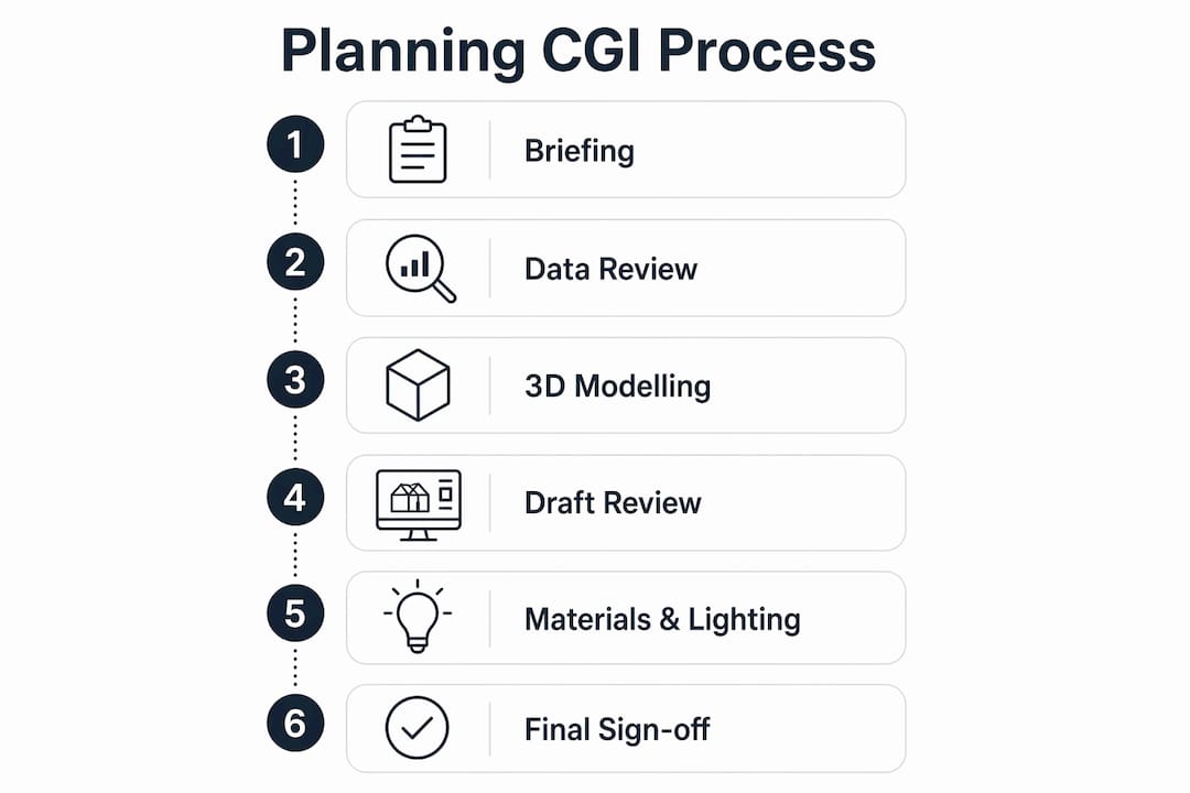
Step 2: Data collection and validation. The studio reviews all architectural drawings, mapping data, and site photography for completeness and consistency. Any gaps or contradictions are flagged before modelling starts. This step prevents the expensive scenario of rebuilding a model mid-project because the drawings changed.
Step 3: 3D modelling and context integration. The architectural model is built and placed within its site context using OS mapping, terrain data, and surrounding building geometry. Accurate mapping integration is not optional for planning submissions. It is the technical foundation that makes the image defensible.
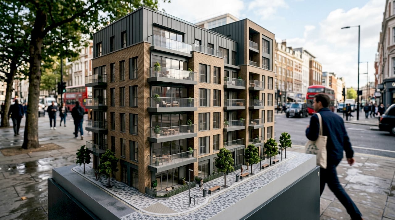
Step 4: First review with stakeholders. A grey-shaded or draft-textured render is shared for review before materials and lighting are applied. Reviewing at this stage catches massing errors, incorrect building heights, and viewpoint problems at the lowest cost point in the process.
Step 5: Materials, lighting, and landscaping. Approved materials are applied, lighting is set to represent realistic conditions, and landscaping is added. For landscape and visual impact assessments, mitigation planting should be shown at project completion and at a future milestone, typically 15 years post-completion, to demonstrate long-term impact reduction.
Step 6: Final review and sign-off. The designated decision-maker reviews the final images. Assigning a single approver at the start of the project prevents the ‘sign-off trap’, where multiple stakeholders provide conflicting late-stage feedback that delays submission and increases costs.
Step 7: Delivery and integration. Final images are delivered at the resolution and file format required by the planning authority. The studio provides any supporting technical documentation, such as camera position records for verified views, that the authority requires alongside the images.
Key documents to include alongside CGI in the planning submission:
- Camera position records and lens data for verified views
- A viewpoint location plan showing where each image was taken from
- A statement of methodology for any LVIA photomontages
- Material schedule cross-referenced to the CGI images
What common challenges arise with planning CGI and how do you avoid them?
Planning CGI fails in predictable ways. Recognising the patterns early saves time, money, and approval chances.
- Inaccurate scale or site context. A building that looks the right size in isolation can appear too large or too small once neighbouring properties are modelled correctly. Always validate the model against OS mapping before finalising any view.
- Conflicting stakeholder feedback. Without a single decision-maker, architects, planners, and clients each request changes that contradict each other. The result is a model that satisfies no one and misses the submission window.
- Overly atmospheric visuals. Dramatic lighting, heavy foliage, and wide-angle lenses can make a proposal look more appealing but less accurate. Planning officers are trained to spot images that flatter rather than inform. CGI visuals are most effective when they focus discussions on design realism, not assumptions.
- Insufficient viewpoints. Submitting too few views leaves gaps that planning officers fill with their own assumptions, often unfavourable ones. Cover all key visual receptors identified in the pre-application process.
- Ignoring TGN 06/19 for LVIA submissions. Where a landscape and visual impact assessment is required, TGN 06/19 methodology is the accepted standard for transparency and replicability. Submitting photomontages that do not follow this methodology risks the images being rejected or challenged at appeal.
- Late commissioning. CGI commissioned after the submission programme is already tight leaves no room for revision rounds. The images that reach the planning officer are often first drafts.
“Planning visuals are most effective when commissioned during the plan preparation phase, before submission deadlines become tight. Early CGI is more flexible and supports multiple elements of the submission, from public consultation to design and access statements.”
Key takeaways
Successful planning CGI requires accurate inputs, clear briefing, and early commissioning to meet UK regulatory standards and support approval.
| Point | Details |
|---|---|
| Accurate inputs are non-negotiable | Provide coordinated drawings, OS mapping, and material specs before modelling begins. |
| Viewpoint selection drives the narrative | Choose 3–8 views that cover all key visual receptors identified in pre-application advice. |
| TGN 06/19 applies to LVIA submissions | Use this methodology for photomontages to meet transparency and replicability standards. |
| Assign one decision-maker early | A single approver prevents conflicting feedback and protects the submission timeline. |
| Commission CGI during plan preparation | Early commissioning allows revision rounds and supports multiple submission documents. |
What I have learned from years of planning CGI projects
The most consistent mistake I see developers make is treating CGI as a finishing touch rather than a planning tool. By the time the images are commissioned, the submission programme is already compressed, the planning consultant has not been involved in viewpoint selection, and the architect is still revising the drawings. The result is a rushed set of images that the planning officer cannot rely on.
The projects that go smoothly share one characteristic: the CGI brief is written at the same time as the planning programme. Viewpoints are agreed with the planning consultant before any modelling starts. The architect, planner, and client have a shared understanding of what the images need to achieve and who has authority to approve them.
Landscape CGI deserves particular attention. Developers often underestimate how much a landscape visualisation can shift a planning officer’s reading of a scheme. Showing mitigation planting at year one and year fifteen, rather than just at completion, demonstrates that the developer has thought seriously about long-term impact. That level of detail builds credibility with the authority and reduces the likelihood of conditions being attached to the consent.
Realism and regulatory transparency are not in conflict. The best planning CGI is both visually clear and technically defensible. If an image needs dramatic lighting to look good, the proposal probably needs more design work.
— Paride
Visualtrick’s planning CGI services for developers and planners
Visualtrick produces architectural visualisation for UK planning submissions, combining 3D architectural modelling, Ordnance Survey mapping integration, verified views, and landscape renders into a complete submission-ready package.

Every project begins with a structured briefing process that defines viewpoints, standards, and sign-off authority before modelling starts. Visualtrick works directly with architects, planning consultants, and developers to produce images that meet local authority expectations and support approval. Whether your scheme requires a single street-level view or a full CGI for architects package with LVIA photomontages, Visualtrick delivers images that are accurate, clear, and planning-ready. Contact Visualtrick to discuss your submission requirements and receive a tailored quote.
FAQ
What is architectural CGI for planning submissions?
Architectural CGI for planning submissions is the production of accurate, context-based 3D visualisations that show a proposed development’s scale, materials, and visual impact to planning authorities. These images support planning applications, public consultations, and landscape and visual impact assessments.
How many CGI views does a planning application need?
Most UK planning applications for medium-to-large developments use between 3 and 8 CGI viewpoints. The exact number depends on the site’s visual receptors and any requirements set out in pre-application advice from the local authority.
What is TGN 06/19 and when does it apply?
TGN 06/19 is the industry-standard methodology for producing photomontages used in landscape and visual impact assessments. It applies when a development requires an LVIA as part of its planning submission, and it sets out requirements for camera positioning, lens calibration, and image accuracy.
How early should I commission planning CGI?
Commission CGI during the plan preparation phase, before the submission programme becomes tight. Early commissioning allows multiple revision rounds and means the images can support design and access statements, public consultation, and the main planning application.
What causes planning CGI to be rejected or challenged?
The most common causes are inaccurate site context, insufficient viewpoints, and photomontages that do not follow TGN 06/19 methodology. Images that appear to flatter the proposal rather than represent it accurately are also likely to be challenged by planning officers or at appeal.
